
All prints are made-to-order and will require one to two weeks’ production time before being shipped. Each order will be acknowledged after payment has been received to confirm the shipping date. To customers who order prints of the same image subsequent to their original order, there may be slight variations in image density and/or contrast when compared to the initial print. If exact matching prints are desired, these should be ordered at the same time.
All prints are shipped flat, durably mounted on high quality backing board with two inch borders top and sides and a five inch border at bottom.
Custom Matting and Framing crafted to fit the Mount Board Size shown will be required to complete the presentation. The bottom border will show below the lower right corner of the image the photographer’s signature. Due to slight size variations please await receipt of your mounted print before ordering custom matting and framing.
Reproduction or publishing of prints sold on this website and related websites in whole or in part in any form, photographically, digitally, or otherwise, is strictly prohibited. The purchase of a print on this website is intended for buyer’s exclusive use in a single display location, and buyer accepts these conditions without modification. Please see Terms and Conditions of Sale for further clarification and additional terms and conditions for the sale of prints.
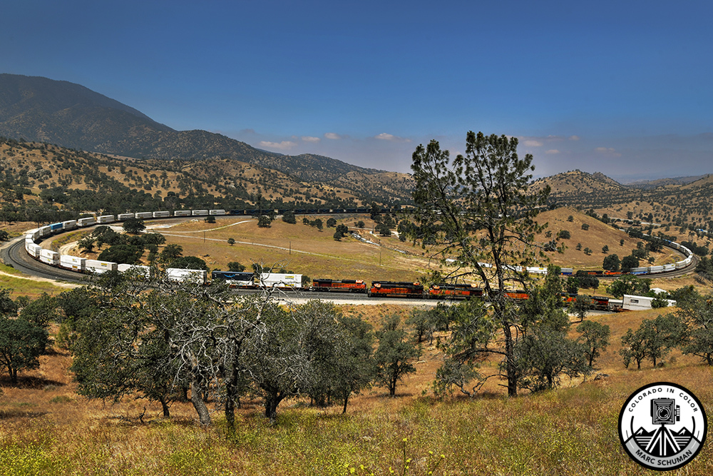
Tehachapi Loop Rail Line, Kern County, California, May 30, 2026.
The famed Tehachapi “Loop,” a rail line that passes over itself to gain 77 critical feet of elevation within the limits of a small area and the physics of steel-on-steel wheel slippage on grades in excess of 2 percent, is located between the agriculturally rich San Joaquin Valley and the Mojave Desert to the east. Beyond the Mojave, deprived of rain by the Sierra Nevada Mountains to the west, lie the tremendous markets of much of the United States. Without this rail line in earlier times, the vast agricultural output of the San Joaquin Valley could not reach markets to the east of California via the “Pacific Fruit Express” trains that traveled these tracks. Modern truck transportation and a network of highways gradually lessened the need for agricultural rail transportation, but a quick observation of today’s rail traffic on this line shows huge amounts of intermodal container freight–thirty to forty trains per day traveling east with full containers and west with empty ones returning primarily to the Port of Long Beach. In just two years beginning in 1874, two civil engineers designed and 3000 Cantonese Chinese laborers built a network of tunnels and bridges over Tehachapi Pass including the famed loop seen here. Two BNSF intermodal trains meet in the foreground. Two of the three eastbound engines heading down grade toward frame right have passed behind the four westbound engines heading upgrade toward frame left. From the deafening roar of these freight engines’ power plants, it is clear that full throttle is needed to negotiate the challenging 2.2 percent average grade on this double track loop. The tunnel at center (barely visible from this position) under or over which trains pass themselves, depending on their direction, is only a single track–a bottleneck in rail operations. Taken with a Nikon D850 DSLR using a Nikkor 16-35mm zoom lens at 16mm, this is a super wide view of the loop.
The logo is a security watermark and will not appear in your print.